


| |
HOME
|
|
Shasta Lake's Hidden |
|
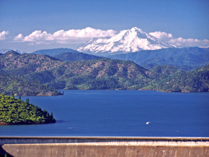
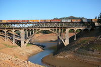
| Three Shastas (Dam, Lake, and Mountain) in 2006. |
|
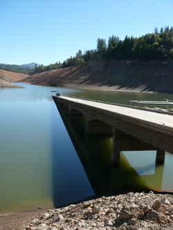
Pollock Bridge emerging out of Shasta Lake in 2008. |
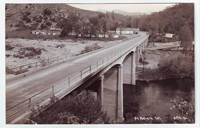 |
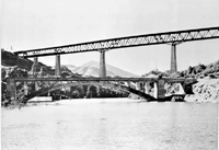
| A postcard view of the Pollock bridge before it was submerged. GO TO a larger view |
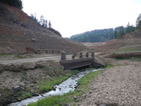 |
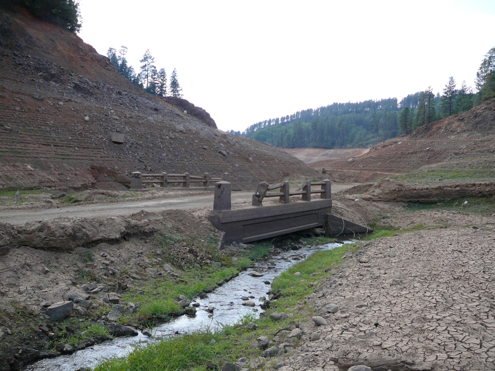
| A small bridge in O'Brien inlet has been hit by one too many boats. GO TO a larger view |
 |
| A masonry retaining wall reappeared in 2008. GO TO a larger view |
 |
| The deck on the 1925 Doney Ck. bridge was raised for possible high water after the dam. GO TO a larger view |
 |
| A double decker car/train bridge replaced the original (disappearing) Pit River bridge. GO TO a larger view |
 |
| A 1917 bridge at Charlie Ck. is further up the canyon from the one currently used. GO TO a larger view |
 |
| The Salt Ck. bridge reappears now and then in a shallow part of the lake. GO TO a larger view |
Question: Why do California Highway 99 fans shamelessly enjoy a good drought? |
|
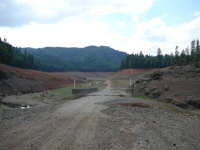
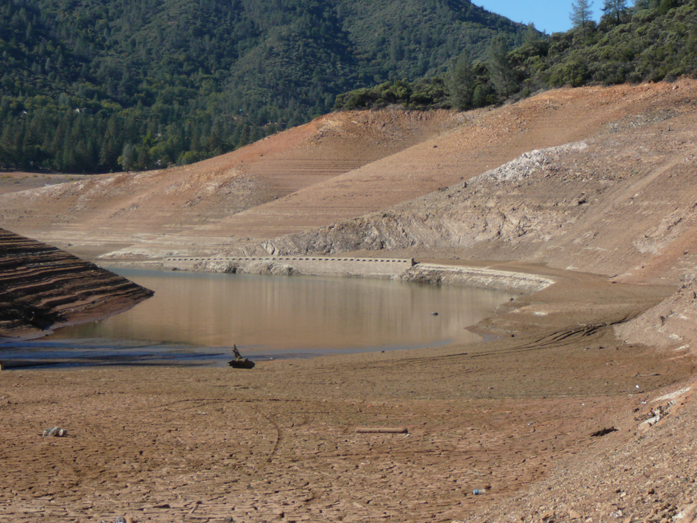
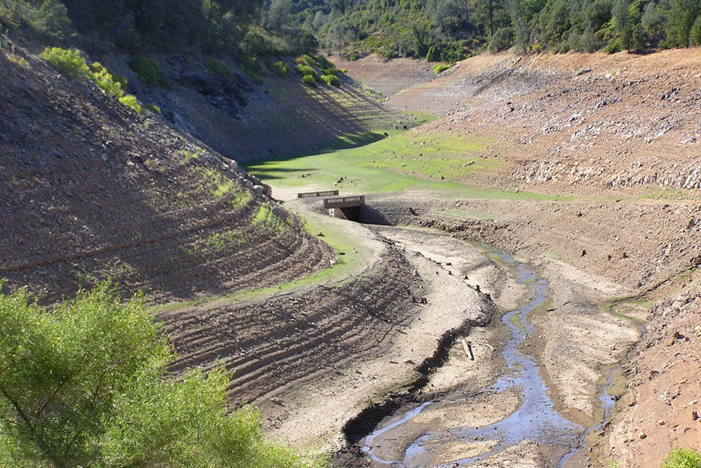
Cool and shimmering Shasta Lake collects the water from three pristine northern California rivers and countless creeks. It is situated about 100 miles south of the Oregon/California border in the shadow of 14,179’ volcanic (and some say “mystical”) Mt. Shasta. When the lake is full, boaters, swimmers, jet and water-skiers flock to the huge 30,000-acre body of water with its 365-mile shoreline. But Shasta Lake and Shasta Dam, the country’s second largest concrete dam, were built mainly to provide irrigation water for downstream Sacramento Valley farmers. When there is a lack of rain, farmers get their rations but the shoreline recedes dramatically and rather unattractively, and recreationists suffer. Unless, of course, ones idea of recreation is tracing the route of an historic highway, a pursuit of which I suspect many readers of American Road are fond! Highway 99 was the major north-south highway in the far west during the US Highway era. Interstate 5 is the late-20th century version of this road. Heading north from the state capital of Sacramento the road generally followed the Sacramento River to its source near Mt. Shasta. Native Americans (naturally) were the first to use the route, then fur trappers, immigrants, gold seekers, settlers, the Southern Pacific Railroad, the Pacific Highway, and US99. 1914 saw a flurry of highway construction in the piney canyons north of the town of Redding, which sits at the head of the Sacramento Valley. The new State Highway (later US99) followed the basic routing of an early toll road, the Stone Turnpike, and the Pacific Highway. With many streams along the way a number of bridges had to be built. They were constructed sturdily out of concrete. The old highway going north reached the river canyon-and-mountain realm ten miles from Redding at the Pit River crossing, just above where the Pit joins the Sacramento. The Pit River Inn dispensed gas, food and sundries at the southern approach to the handsome concrete arch. Roadies may dream of walking its deck again but this 1916 relic is so far under the lake that it will likely never be seen again. Not so for some of the other Highway 99 bridges built from the mid-teens through the mid-1920s. Backtracking a bit, Shasta Dam was a late Depression-era Bureau of Reclamation federal project, along the lines of the Hoover and Grand Coulie Dams. The meticulously planned undertaking was to sink over 18 miles of US99 and 26 miles of Southern Pacific Railroad track. Work started in 1938. WWII slowed progress to some extent, with workers quitting to join the service. But on January 8, 1943, 15.5 miles of all-new realigned highway and a new Pit River Bridge opened to the public. Hastened by wartime urgency and the need to keep transportation routes open, a massive $20,000 tarp had been erected above the bridge allowing surfacing work to be carried on in the rain. The old bridge was slowly inundated--it took several years--but the newer one, which carried 99 (and now carries I-5) 325 feet above the original bridge is a marvel in its own right. The narrow deck and sharp right angle turn on the north side brand this stretch of road as “old fashioned”, an I-5 bottleneck on holiday weekends. The bridge is doubled-decked and dual-purposed, the railroad taking the lower level and exiting straight into a tunnel on the south side. O’Brien inlet of Shasta Lake. Due to dry conditions the bridge, rather than hiding underwater in an arm of the lake, was serving once again as a small creek crossing. Later that day we found another usually submerged bridge in the drought-stricken Salt Creek inlet. These had been the next two structures north of the original Pit River Bridge on the old highway. Located in shallow parts of the lake, they appear not infrequently in these dry times we’ve been having. As the shoreline continues to recede the old 99 roadbed itself can be followed out into the lakebed well beyond the bridges, to the delight of both fishermen and roadies. But 1977, a year of severe drought, was the biggest year for sunken highway treasure. In September of that year the skies were smoky from catastrophic forest fires and Shasta Lake was down 238 feet, the lowest level recorded since the lake reached full capacity in the mid-1940s. The old Pit River Bridge remained below the surface but one that had crossed the Sacramento River at Pollock reappeared from the depths for the first time in 30 years. So did many miles of original highway road bed, rock retaining walls, deep road cuts, formerly flooded train tunnels, a railroad trestle, bits of the old mining town of Delamar and, near the dam, the top of the “head tower” of the cable system that had been used to move buckets of concrete for the dam pour. 2008 was another banner year with the lake down 158 feet, the lowest since 1977. The Pollock Bridge again emerged at the bottom of the old highway road cut at Sugarloaf Marina and was re-invented as a boat ramp. Across the narrowing arm of the lake from the marina once sat the little town of Pollock. Near the town site a curving stretch of fine-looking rock masonry retaining wall showed up, a tantalizing sight in the distance across the water. Throughout the fall of 2008 curious locals cruised the edges of Shasta Lake looking for relics, and road fans made pilgrimages from other areas. On the north side of the lake, Lakeshore Drive is an extant stretch of old 99 that was not submerged. On it are two high concrete arches crossing Doney and Charlie Creeks. These bridges date from the mid-1920s. Being on the far upper and outer edge of Shasta Lake they were tall enough that they could be adapted and used even after the lake filled; both bridges had their decks raised to accommodate the possibility of high water. It’s notable that each of these two bridges also has a smaller and older “sibling” bridge dating from the teens. The siblings reappear in low water years; each is located walking distance up the canyons from their 1920s bigger (but younger) brothers. These two sets of bridges are an interesting illustration of evolving roadways. The earlier alignment wound up into the canyons some before the creek crossing then wound back down the other side. This older road would be longer and curvier but the bridge could be smaller, lower, and cheaper and easier to build. A little more of the Pollock Bridge and other relics showed each day until October 30,2008 and then it started to rain. The treasures slowly disappeared beneath the surface, and the seekers went home for the winter. A number of other Highway 99 “concrete treasures” are found in this part of California, especially the many bridges situated farther up the Sacramento River Canyon. Redding sights include a stretch of original concrete paving and the five-arched Diestelhorst Bridge. This is rich country for the old highway enthusiast. To Part Two MORE Shasta Lake Emerging Highway Photos |